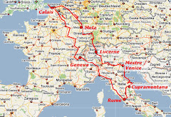
Saturday, 26 July 2008

WEDNESDAY JUNE 11TH: THE CITY THAT NEEDS NO NAME

Following a very pleasant breakfast in the hotel’s elegant breakfast room, and also following our receptionist’s advice of last night, we went into the City by the #8 tram that runs along the Circonvallazione Gianicolense and crosses the Tiber by the Ponte Garibaldi. We got off at the Largo di Torre Argentina, “Square of the Silver Tower” (Argentoratum being the old Roman name for Strasbourg; a Strasbourg-born bishop built a palace with attached tower there in the 16th century. It's still there).

We’d wound up at the Largo because it’s the city terminus for #8 trams; but what a discovery awaited us! Back in the late 1920s, workmen doing demolition uncovered an Area Sacra, a sacred quarter, of the Roman republican era (3rd or 4th Century BC). The area isn’t enormous, but houses the remains of no fewer than four temples, including a circular one on the inner wall of which 2,000-year-old murals can be seen from the street. Ground level is a couple of meters below street level, but most remarkably, the fluted columns rise from the weeds and rubble to stretch metres above. How do you lose something that big for a thousand years?

(You can find an account, and an interactive 360 degree panorama of the Largo, here. You can see the tram and bus terminus on the opposite side of the Area Sacra from the camera location.)
There are, naturally enough, several information boards round the Area, and we learnt from them that it was on a platform behind one of the temples that Julius Caesar is believed to have been assassinated.

But that wasn’t all … Anyone who saw the Python Life of Brian at a cinema may remember an accompanying travelogue (apparently cut from the DVD versions) which starts out as a straight documentary on Venice, with several comments about the gondolas, before Cleese cuts in with “round the corner—more f**king gondolas!” From there, the travelogue shifts to “the City That Needs No Name: Rome!”, and a view of the wild animals in the Coliseum: namely, cats. But not the Big kind ...

It turns out that Rome has a major problem with homeless moggies, who have in fact found a home in the ancient ruins of the Area Sacra. They’re all over the place! – and there’s even a charitable society that looks after them. First thing we saw, and it turned out to be a totally unexpected highlight!

From the Area Sacra, we walked northwards up the narrow via di Torre Argentina and into the via della Rotonda, following the map from our AA CityPack Guide, till we got to the piazza della Rotonda and our target: the Pantheon.

Which, frankly, is indescribable. So here goes … The strength! the grandeur! the grace! the, the, the, … Okay, we give up. There are pictures of it all over the Internet, but they can’t compare with actually being there, especially on the inside, with that enormous beautiful vault and its central Eye of Heaven, the sole source of light for 2,000 years save for occasional votive candles (the building having been a Christian church for most of its existence). The Eye (Latin: oculus) is 30 feet across, and completely open to the sky. So what happens when it rains? There are cunning small drain-holes drilled into the mid part of the floor, which slopes very very subtly towards them.

While we were there, we spotted a seagull circling inside the dome, more than a hundred feet up, and trying to find a way out. Sometimes rising towards the oculus, sometimes drifting back down, and obviously very tired, it tried more than once to find rest on one of the recesses on the inside of the dome, but each time the angles defeated it and it fell, recovering itself to rise, circle, and try again. Eventually it found a perch, and was still there when we left. (You can just see it in the photo, at full size.)

We made our way down to Trajan’s column. This was a second must-see, because of the totally mad reproduction we’d seen in the Victoria and Albert Museum. The Victorians (some of them) developed a passion for making full-size plaster casts of European sculptural and architectural works, and the VAM has two huge adjoining galleries (a wonderful place to visit) full of things like the complete front of some cathedral, life-sized—and Trajan’s Column, in two sections because it’s too tall to fit otherwise! (We’ve chosen the close-up we took of its base, the real Trajan's Column, that is.)

Our way to Trajan’s Column took us through a number of side- and back-streets, and in one of them, the via del Ara Coeli, we stopped simultaneously to look at something that had caught our eyes in the window of a gioilleria, Aliberti’s. It was a silver sculpture showing a pair of nude lovers, the upper parts of their bodies fusing into two intertwined hands. We went in (which required us to go through a security procedure) and bought, not the full-size one we’d seen in the window, but a smaller and more affordable version. It’s made by the silversmiths Ottaviani; you can see it (“Amantes / Lovers”) in the lower half of the catalogue page at their site. (It’s safe to open the page from the link.)

From Trajan’s Column, at the north end of his forum, we walked the via dei Fori Imperiali, The Street of the Imperial Market-Places. The street’s dead straight; Roman, you see—but modern—1930s—and scandalous because it wiped out so many precious monuments and buildings, running over or through the fora of Trajan, (Julius) Caesar, Augustus, Nerva, and Hadrian (pictured), and alongside the huge Foro Romano which they supplemented because it had become overcrowded. We passed statues of the emperors, including the young Augustus; and each step brought us closer to the colossal ruin at the end of the street: the Coliseum, of course …

The entry area was crowded and the queues were long. Margaret found somewhere to sit while Don queued for tickets (and the inevitable guidebook). Once inside, we found a lift that took us to the upper part of the huge amphitheatre. The real-ness of the ancient stones was wonderful; despite its crumbling state (most literally “dilapidated”), it gave an impression of great strength and stability. But we didn’t go down into the “below-stage” tunnels (now open to the air) to see the Python cats …

From the Coliseum we went up (literally) into the streets to the south-east in search of “lunch”; but it was now 15:30-ish, and most restaurants were closed. However, we found a little pizzeria with pavement seating and had genuine Roman pizza before making our way back down to the via Celio Vibenna, skirting the Coliseum, and caught an open-top tour bus—one that included a stop close to the Largo di Torre Argentina, where we’d be able to catch the #8 tram back to Trastevere (or so we thought).

The tour took us round past the Circus Maximus (which Don was keen to see, though it mostly resembles a grassy park at present: but the Italian authorities have just announced plans for a restoration project). You can still see the shape of the ancient racetrack, where races were last held in the 6th Century, but even more impressive are ruins of the palatial imperial residences on the Palatine Hill behind it. (Most literally “palatial”: the word palace comes from “palatine”).

The bus took us down to the river, where the sacred and monument-covered Isola Tiberina could be seen, then back into the narrow streets, past the Chiesa Nuova (the New Church: it’s only 400 years old …), and over the Tiber by the ponte via Emanuele II into the Vatican. Photography was very difficult from the moving bus (we have a few pictures of brownish blurs), but it stopped on the bridge (because of traffic) so we were able to snap the amazing Castel Sant’ Angelo—originally the mausoleum of Hadrian, then a fortress, and now a museum. The angel on the top is St Michael, who was credited with ending a plague in the 6th Century.

From the Vatican we re-crossed the Tiber by the marvellously-named ponte Principe Amadeo Savoia Aosta, and trailed northwards along the east bank; but at some point (we’re not sure exactly where) the tour was hijacked by history. The bus ran into a dense crowd of near-stationary traffic, and we could hear and see not only police vehicles but army trucks and soldiers moving about. Eventually, the bus hostess came up (we were, of course, on top) and told us that the streets we should have taken were closed off because of the George Bush protest rallies (we hadn’t even known he was in town). We don’t know what route we took, though part of it was along part of the alternative “B” route that the buses take on some days.

Eventually, we got back to the Isola Tiberina (not the Largo di Torre Argentina, as we;d intended), got off the bus, and took a short detour through the fascinating Ghetto (the Jewish Quarter); but it was now too dark for satisfactory photography with our little digital camera. Before long we were back at the Torre Argentina and on the tram. We got off at the wrong stop initially, but recovered and found our way back to da Claudio’s for a second satisfactory dinner (Margaret got the ossa bucco that had been “off” the menu last night) and a session of writing up postcards over limoncello and white wine …

Saturday, 19 July 2008

TUESDAY JUNE 10TH: FAREWELL CANTINONE, HELLO ROMA

Four-and-a-half days can seem a long time when they’re so packed with experience, and yet nowhere near long enough when there’s so much to see and do. We’ve grown to love the Italian Marches country, its hollow lands and hilly lands, its olive groves and cedar rows and farmsteads and poppy-purpled meadows and crazy, beautiful, mountain-top villages and cities within their massive ancient walls. And we’ve seen nowhere near as much of Ian and Jane as we’d like—and suddenly, it’s time to leave them, and their lovely surroundings, and head west through north central Italy.

We make a swift tour of Il Vecchio Cantinone, The Old Wine-Cellar, making up for our lack of photos of the place: our downstairs apartment, the lounge, the patio breakfast area, the pool ... We snap the wee mother cat with the braver of her two delightful kittens (the one that looks nothing like her), cautiously peering in at the lounge door (how long, we wonder, before Jane’s resolve breaks and they become house cats?). We pose for mutual photos. We pack the car. And then it’s time to go.

One thousand, four hundred, and fifty miles on the clock since we rolled off the ferry at Calais, eleven days ago; and about the same to go before we roll back on, in six days’ time. But today’s not a day for messing about; we’ve got two clear targets: Assissi, and then Rome. We hug and wave goodbye, and then we’re off up the via Esinante, onto the SS76, and speeding south-westwards, through Fabriano and Fossato di Vicolo, and into
Umbria.

It’s motorway for two thirds of the way to Assisi, then at
Gualdo Tadino we turned off onto a cross-country road and began to climb.

Assisi is another of those amazing walled cities strung out along the top of a ridge. Our first clear view was from a scenic pull-off area (about the only one we’ve seen in this highly scenic country) where there was also an abandoned farm-wagon. Below us, a deep valley stretched to east and west, its sides rocky, its flanks green. At its west end, a ridge extended northwards from the southern valley wall where we stood. Atop it was a walled city of pale stone: castellated buildings, square towers, gleaming in the sun; a city from mediaeval romance.


As usual, we hadn’t done our homework; we honestly enjoy being taken by surprise by the places we visit. We entered the town at what turned out to be the top end, but hey, where do you put the church? On top of the hill, right? Wrong …

We drove in through the Porta Perlici, found a parcheggio (our Italian vocabulary was now becoming consolidated) in the piazza Giacomo Matteotti, and made for the nearest street leading down (literally) into the city. The day was bright and sunny, but the shaded air was cool in the narrow lanes between the stone-built houses.


A little way down, Margaret spotted an embroidery shop which also sold postcards and guidebooks. We went in and were charmed by some (to us) unusual styles of embroidery. The very pleasant lady in the shop had little English, and we much less Italian, but between us we learned that both styles were local, and the one was called

punto Catherina dei Medici, the other punto Assisi. But she had no books explaining either. We bought a guidebook instead, and continued down the street, passing through the piazza San Rufino with its cathedral, and eventually finding ourselves in the piazza del Comune.

Here there was a libraria (bookshop), the EREDI di E. ZVBBOLI, its name inscribed on beautiful tiles above the doorway (with more tiled inscriptions either side of the door), along with the slogan, Touring Club Italiano. This perked up Don’s interest, because he was keen to get a copy of the book,
The Marche, which had helped us find our way around Jesi, Urbino, and the Frassassi Circuit. And, of course, Margaret was hoping for one or two local embroidery books.

Sadly, Don was disappointed (many other Touring Club books, but not The Marche). But Margaret was in luck, and bought a
book with several traditional patterns in punto Assisi. She has a considerable collection of cross-stitch patterns, and completed cross-stitches, recording places we’ve been in England (and also several from Paris), but hadn’t really been surprised not to find any in Italy. Now, though, she’s all fired with enthusiasm to create an Assisi-work picture of Assisi for the collection. And it wasn’t a total loss for Don, either: he collects leather bookmarks of places we’ve been, but they too seem to be an essentially British thing, so we were both thrilled not only to find a leather bookmark of Assisi (we bought one), but to find also that a local artist made beautiful hand-painted bookmarks featuring Saint Francis and city scenes. We were so elated, and they were so lovely, that we bought two!

We retired with our prizes to an umbrella-shaded table outside the Caffe Minerva, where we looked through the books and chatted over lunch. The café is named after the
Tiempo di Minerva (“Temple of Minerva”, goddess of wisdom), which faces it across the piazza: a survival from pagan Roman times, long ago converted to Christian use as the church of Santa Maria Sopre Minerva. We mounted the steps that lead up to the classical façade (AD 30-something), went inside, and absorbed the hushed calm and admired the beautiful artwork. Not even the electrically-haloed Madonna forming the altar-piece seemed out-of-place.

But the main target for a first visit to Assisi has to be San Francesco, St Francis, and the magnificent basilica that houses his remains. Our walk had taken us downhill and westward, about half the distance to the Basilica. We continued along the via S. Francesco, catching occasional glimpses down narrow side-streets (“the small quiet side streets are amongst the best that Italy has to offer”) of beautiful small houses, stairways, arches, and the countryside that surrounds the city, until the Basilica came into sight .

By and large, the external appearance of Italian churches and cathedrals lacks the architectural beauty of northern European cathedrals, being built in Romanesque rather than “Gothic” style: massive walls, round arches, square towers, occasional domes, and relatively simple ornamentation, rather than pointed arches, columns and pinnacles, flying buttresses, an emphasis on verticality, and elaborate embellishment. The interiors (like that of Santa Maria Sopre Minerva) make up for this; but in
S. Francesco, as in the Grotte di Frasassi, photography is forbidden, and we respected that condition, so we have only external photos to show. The artworks are as numerous and beautiful as one might expect, but the highlight is to visit the crypt which holds the tomb of St
Francis, deliberately hidden to protect it soon after his death, but rediscovered in 1818.

Outside again, in the piazza alongside the lower basilica (down the ramp in the photo above), and with a small collection of magneti, we faced the prospect of a lengthy uphill walk back to the car … and turned our backs on it. There were a couple of taxis in the square, so we hired one, and experienced the rather pretty road up the outside of the town, the Viale Vittorio Emanuele II, which gives lovely views of the agricultural plain to the south, across to the basilica of Santa Maria degli Angeli.


Back in the car, we left the car park and (in Italian, and feeling very proud of our abilities) consulted a passing gentleman for the best way out of the town towards Rome. The drive itself was uneventful and was much more “journey” than “sightseeing”, though we avoided the boring and expensive Autostrade and took secondary roads through Peruggia, Terni, and Narni (where we had to stop at one point—near Testaccio, just south of Narni—for a photo of a romantic rocca perched high among woodland).

We approached Rome from the north, along the via Flaminia (an ancient pilgrim route, we later learned). From there we had maps and directions that should take us clockwise round the A90 orbital roadway so we could approach our hotel (the
Villa Rosa in the Trastevere) from the south by a reasonably major road without having to cross the inner city and brave its traffic, a prospect which terrified us. As we discovered, we needn’t have worried too much on that score. We mislaid the A90—as we later found out, it’s actually signposted as “GRA”, not “A90”—and found ourselves heading ever deeper into a maze of streets and a world of lostness … Traffic was thick, but, we were pleased to find, orderly, and since by now Don had quite a lot of experience driving on the right, the driving itself wasn’t too much of a strain—not for someone who’s braved inner London traffic for a few years now!

What was more of a strain was the growing, pressing, need for a loo … Eventually we found somewhere we could stop outside a ristorante, used its facilities, and were able to settle down to finding out where we were (we had a map) and where we needed to go. Before long, Margaret found a street that we could also find on the map, and worked out a route to the hotel, which turned out to be only slightly confounded by the usual vicious one-way system that old cities usually have.

We finally got to the hotel, in a quiet side street above a major road (the Circonvallazione Gianicolense), about 9 o’clock at night. The friendly and helpful male receptionist, who spoke excellent English (they all do) and didn’t laugh at our tired attempts at Italian (they never have), gave us good advice about getting into the city the next day by public transport. But (he told us) the hotel had no WiFi, despite the web site we booked through having said that it had. That was a bit of a blow (once more, no blogging), but we realised that, if the past week or so was anything to go by, we’d be getting back to the hotel quite late and not feel like blogging anyway.

Although it was late, we were hungry; so we left the hotel and walked down a series of steps to the Circonvallazione, where we had dinner across the road at the Trattoria e Ristorante Da Claudio, a traditional-style ("tipico"?) Italian family restaurant, where again the staff were friendly and spoke good English. And then we went back to the hotel, and to bed.

Sunday, 13 July 2008

MONDAY JUNE 9TH: AN ABBEY, URBINO, & ADRIATIC

(Remember to click on the pics to get them full-size.)

How much blissing-out can you do in a day, and live?

It was with a sense of determination that we set out today to find the elusive ruins of the Abbazia di Val di Castro. We’d no idea how lovely the day would be—except that they all have been, so far.

Yesterday we’d lost track of the Abbey round about Fabriano, losing ourselves around the railway and the SS76 road. But today we sat down with the maps and worked it out, step by step, village by village: first head for Cupramontana, then pass it by and continue south towards Apiro; turn for Piaggia, passing through Madonna della Fonte; cross-country to Domo; Montefiascone; Precicchie; San Giovanni; Vigne … Tiny frazione with romantic, poetic names, on mountain-tops or in valleys, amidst awe-inspiring scenery …

But we stopped for no photos in this part of our trip, however lovely or awe-inspiring the views. Our ambition was to discover those elusive ruins of The Abbey (which was founded w--a--y back in 1009 by a certain Saint Romuald, dissolute-nobleman-turned-saint, who died there in 1027). Not that we had much idea of what we might find, beyond “ruins”: it was just so galling that we weren’t able to find it yesterday!

And then—success! We turned off the “main road” (okay, main country road) at Vigne, and descended towards a group of buildings amongst the fields and meadows in the valley below us, behind the screen of trees. We’d found it!—St Romuald’s abbey, no longer ruined (Jane’s and Ian’s book was out of date), but now restored and refurbished as an agriturismo, a sort of government-sponsored farm-stay.

We drove down to the abbey courtyard and took several photos, revelling in the sunlit peace of this remote valley where we could hear nothing but birdsong, the lowing of cows, and the breeze in the cypresses … Driving back up the road we went down by, we paused again to view the valley and the abbey and absorb their tranquillity.

(Ian told us, afterwards, that we were the first of their visitors to have succeeded in finding the Abbey. We felt proud … Such skilled tourists!)

Our next target for the day, after the Abbey, was Urbino, a good 60 km to the north-north-west, as the crow flies. Unfortunately (or otherwise), we’re not crows, and nor’s our faithful Chariot. Google Maps will tell you that the “quickest” route (just over an hour and a half) goes way out eastwards to the coast, north-west up along the coastal highway, and then south-west (inland) from Rosciano: three sides of a square (east, north, west), comprising over 130 km. But we’re made of tougher stuff, and determined on a more interesting overland route, up mountain and down valley, roughly north-west all the way: only 100 km, but over 2 hours if we didn’t stop on the way … (We did.)

From Vigne we headed southwest, up to Poggio San Romualdo (poggio translates as “hillock”. Central Italians have a strange idea of what’s a hillock; San Romualdo’s altitude is almost 1000 metres), and from there down a wild succession of hairpin bends well known to mountain cyclists, through Albacina with its castle, and briefly onto the SS76, through Fabriano, then northwards through Sassoferrato (thus completing the “Frasassi Circuit”) and so into unknown country, heading north for Pergola

Contemplating the tiny ancient villages we went through, the steep hills and olive-dressed valleys and distant mountains, adjectives like “awesome” come easily to us now; believe us, we’ve done awesome!

Driving round steep, narrow, twisting roads with precipitous drops on one side or the other, we wondered what it would be like in winter. The six-foot black-and-yellow striped poles that marked the edges of the road at many of the higher points gave us an important clue, we felt ...

A feature of our first day’s journey (weeks ago now, it seems) was the fields rouged with poppies, not only in Flanders but also into Luxembourg and France. Here they were again, and with many other wildflowers in the roadside verges. We had a long way to go, and didn’t stop often (and we were nervous of stopping on these constantly winding narrow roads), but at one spot we saw a farmhouse in a poppy field, and as we rounded a bend found a white van stopped, with an elderly couple picking cherries from a roadside tree. The road was relatively straight for a stretch here, so we stopped, got out, and photographed the poppies … but (to our subsequent regret), didn’t pick any cherries.

We hit Urbino mid-afternoon, and faced the same sort of problem as we did at Murano: it was a little late for lunch. But, having found a car park outside the walls at the top end of the city (the photo shows some of the magnificent view from alongside the car), we walked down a couple of steep cobbled streets and came to a piazza which had an open restaurant (or, puzzlingly, Macelleria e Polleria, a “butchers and poulterers”—perhaps the place next door? Looks like the same place, in the photo!); but we didn’t note its name. It offered pleasant shady outdoor tables and a friendly waitress with reasonable English, but not much on the menu that was still available. (“Sorry luv, spam’s orff.”) Margaret had pasta, but Don bravely ordered formaggio grillo, translated (on the menu) as “toasted cheese”; it proved to be a decent-sized slab of a softish cheese (mozzarella?) that had been stuck under a grill. Just that, and a plate; nothing else but knife and fork. But an Italian beer helped wash it down successfully.

San Leo (four days ago, or was it a month? We’ve packed in so much!) bills itself as La Citta del Arte, the “City of Art”. So does Urbino, and, we expect, many another Italian city. But not many others will have UNESCO World Heritage Site labels attached to them! The city was completely rebuilt in the 15th Century under Duke Federico da Montefeltro, as an “ideal city and art capital” (according to the The Marche guidebook).

Like every Italian town, it seems, Urbino has a piazza della Repubblica, which in this case is in the dip between the Monte to the northwest (where we came in) and the Poggio to the south. We descended the Monte by the via Raffaelo, went through the piazza, and ascended the Poggio to the piazza Duce Federico, where the ducal palace (in the photo) and the Cathedral lie cheek-by-jowl on the western edge. Equally plain on the outside, both contain many treasures of art which we didn’t see on this visit, though we did enter a shop opposite and buy a souvenir basso-rilievo plaque of the city as a thank-you gift for Jane and Ian. If we visit them again some day, we hope to see it decorating a wall somewhere in the Cantinone.

But our attention was caught by a narrow alleyway between the palace and the cathedral, which led down through a vaulted passage with ridged pathway (against the winter snow and ice) to a footpath along the tops of the city walls. From the footpath, we had a lovely view across the oh!-so-Italian roofs of the western extension of the city, to the hills rising beyond.


We walked round northwards to the via Mazzini, which took us east back to the piazza della Repubblica, and from there made our way back up the via Raffaelo and rightwards up the via Bramante to the Porta Santa Lucia we had entered by. The car took us east towards Pesaro, where we drove onto the SS16, the Strada Nazionale Adriatica Sud, and headed south towards Ancona, catching glimpses of the nearby Adriatic to our left. Somewhere between Torrete and Marotto, we left the main road, crossed under the railway, and entered a little maze of streets which, we hoped, would take us to the beach. We did find one way to the beach, where we stopped briefly before continuing south to Marotto, continuously frustrated by a mix of one-way streets and (apparently) private beaches. Eventually we found a bit of beach where we could buy a couple of gelati, sit, and enjoy the late-afternoon sun.

We took our way back inland to Il Vecchio Cantinone and made a dinner of left-overs from the previous evening before going down to our apartment to blog. Another marvellous day in Le Marche, and our sunniest by far. But tomorrow, the City That Needs No Name: Rome.

Wednesday, 9 July 2008

SUNDAY, JUNE 8TH: UP, DOWN, UNDERGROUND

(Remember: You can click on the graphics to see them full-sized.)

Ian and Jane have a number of books on “things to do” in Le Marche, naturally enough, but the one that caught our attention was The Marche, a “Touring Club of Italy Heritage Guide”, which suggests and describes lots of short tours in the region.

Jane had already suggested we take a look at the Frasassi Caves, which are about a quarter of an hour to the south-west from Il Vecchio Cantinone, down the SS76 road. The Marche included a little tour of the villages and country round the caves, taking in the ruined abbey di Val di Castro via a 20 kilometre detour. It was a cloudy and damp morning, so we spent it doing conscience-stricken blogging (we got as far as Metz—our second and third blog entries!), then went down to the car and drove off.

We eventually found out that you can park just outside the caves; but as we neared Frasassi, we allowed ourselves to be led by the signs which said (in Italian), “Park down this way and a bus’ll take you to the caves”. So we did.

Which was okay; the signposted road took us to a mountain-encircled world of souvenir stalls and food stalls. The next bus was an hour away, so we wandered round the stalls after we’d bought the tickets, sussing out the fossils, fridge magnets, and souvenir books. We sat at one of the food stalls and had excellent spiced pork panini (good tucker, as it turned out) with “due Coka light, per favore”. And then the downpour started.

Somehow, when the bus arrived, we found ourselves on it all alone, and we were rather apprehensive as it pulled out: had we misunderstood something? The bus wound its way up a rain-soaked Apennine mountain road, where the rocky, shrub-studded hillsides were closing in to form the Genga Gorge, and, to our dismay, went straight past the entrance to the Caves, on the other side of the road. But a couple of hundred metres further up, it used a parking area to turn, headed back downhill, and dropped us off.

The Grotte di Frasassi are the largest cave complex in Italy, possibly in Europe. Like the Waitomo Caves back home in New Zealand, they were formed when water trickled down through limestone, gathered itself into underground streams, and gradually cut down further and further towards sea-level. They were discovered in 1975, when some local speleologists, climbing up to another cave, noticed some vegetation fluttering on a windless day. They found a breeze emerging from a hole, and when they dropped a stone into it, it was a l-o-n-g t-i-m-e before a faint echo came back

Like Waitomo, the Grotte have huge galleries, intricate passages, and a mixture of massive and delicate stalactites and stalagmites (“the mites go up and the tights come down”). Unlike Waitomo, they don’t (as far as we know) have glow-worms. But like Waitomo, you’re not allowed to take photos (other people did; we were more conscientious), so you’ll have to be content with this picture of a natural “bridge” through the mountain opposite, taken from the waiting area, and use the Interweb Thingy to see the caves themselves. They truly are amazing.

A return bus took us down to Cheap Tat City, where we bought a rather disappointing book about the caves (the good ones were only in Italian) and an excellent magneto, before getting in the car to continue the tour.

Following the map in the Touring Club’s book, we drove up past the caves, up the Genga Gorge, to Genga itself.

Genga is the name of the comune (local government area, or “town”), which covers about 30 square miles of countryside, and includes the Frasassi Caves (and many others) and twenty-four frazioni (hamlets), with a population totalling around 2,000. The road up the gorge takes you to the administrative centre, Genga town, which lies at the tip of a spur of the Apennines. The town is tiny: it consists of essentially a square of houses built onto the massive city walls (with the usual vertiginous drops to the valley below), with two rectangles of houses inside, and a single point of entry and exit at one corner. One road in and out, three roads inside. We loved the idea that people who live in Genga have addresses like “Number 15 Genga”. We also loved the fabulous view from the tranquil little park beside the town car park.

The circuit took us by little mountain roads with many amazing mountain views, past the hilltop town of Sassoferrato (where we lingered to see the Monastery of San Francesco and its “mural wall”), and down through the “paper town” of Fabriano, after which we rather lost our way trying to find l'Abbazia di Val di Castro.

In the end we didn’t find it, and headed for home and home-made pizzas; but we got back to Il Vecchio Cantinone a little later than we’d expected, to find that Ian had fired up the pizza oven (in the photo) some time earlier, and it was now cooling down.

Still, it was capable (just) of cooking our home-made pizzas, which we enjoyed along with more of the wine we’d bought. Tony and Leslie were there, and we all sat and watched motor racing for a while, before we bade them goodnight and went down to the flat.

Saturday, 5 July 2008

SATURDAY JUNE 7TH: VISITING JESI

We woke very late after the depredations of Friday night, though Ian and Jane—who were expecting additional guests today—weren’t quite as late as we were. Over breakfast (ours—they’d already eaten), they explained that two Italian families would be arriving later on, in connection with the First Communion celebrations taking place tomorrow in Cupramontana.

We noticed they were getting short of a few things in the breakfast line, and offered to do a little shopping. This fitted well with their plans; Ian was going to fire up the barbeque that evening, and the pizza oven the next, so if we were going shopping, we’d be able to get some BBQ food, pizza bases, and our own choices of pizza toppings. Jane gave us instructions of how to get to her preferred supermarket in Jesi (also spelt Iesi, and pronounced, roughly, “Yeah-zee”), including a hand-drawn map—their map of the town having disappeared, probably taken by an absent-minded guest; and so we were off.

Jesi is about 13 miles by road from Il Vecchio Cantinone. A hundred years or so ago, it was a typical small, fortified, hilltop town, though a little different from the hilltop towns we’d already visited. For one thing, its hill is a low narrow ridge (less than 100 metres above sea level, as compared with, say, Cupramontana at over 500 metres). For another, the town walls (13th century, built on Roman foundations, and the best preserved in the region, with towers, buttresses, and houses atop) largely surround the hill, rather than being on it.

The historic town centre, with various palazzi and the Duomo (cathedral), is contained within the walls; but a much larger urban sprawl has developed out of it, cascading down the western hillside and spreading out across the Esino river floodplain. We were interested in the old town, but had to drive through the newer town to get up to it, following the signposts for the Centro Istorico. Jane had recommended we visit the Tourist Information Centre (TIC), and also asked us to pick up a brochure about forthcoming events at the adjoining Teatro Pergolesi.

Having negotiated the newer streets, we entered the old town at its western end, via the triumphal Clementine Arch, and followed the dead-straight Corso Matteoti until we found the Piazza della Repubblica, which we felt might be the right place for the TIC. But we could find nowhere to park, so worked our way down the narrow streets until we came to the free (on Saturdays) car park in the Piazza Baccio Pontelli, just where Jane had indicated—inside the town walls at the foot of the south-east side of the hill, and behind a most impressive tower.

From there we walked back up to the piazza, which was quite an arduous climb for Margaret up the steep hillside, and (it turned out) unnecessarily so; the inadequate map in the Touring Le Marche book we’d borrowed from Ian and Jane misled us into taking The Long way Round. Still, the Tourist Information Centre was just where we’d thought (just as well), so we picked up a much more useful map with associated, well, "tourist information" (what else? But the current “forthcoming events” brochures had all gone …).

Quite unexpectedly, as we were leaving, Don spotted a plaque half-way up a wall at a corner of the square, which gave us both a buzz. It read (in Italian):

“In this house was born the writer Rafael Sabatini (1875 – 1950), whose Capitan Blood and Scaramouche were made famous by the movies.”


Using our nice new map, we left the Piazza della Repubblica and made our way through the old town’s narrow cobbled streets. There were little gems along the way: the elegant 16th-Century portico of the Domus Verronum along the via Pergolesi; the Palazzo Ghisleri Scalamonti, glimpsed through its own archway; and little alleyways with flowered balconies on house walls washed a pale orange shade, or with views down the hillside and across the plain to neighbouring hills.

We came to the Piazza Federico II, the site of the Roman market place, where the Holy Roman Emperor Frederick II was born in an open tent in 1194. This was his mother’s way of dispelling the rumour that (being forty years old) she was faking pregnancy, and thus forestalling any doubts about her son’s real parentage.
Fred 2 “was one of the most interesting characters in history”, we’ve learnt: multi-linguist, statesman, enlightened legislator, poet, scientist (he’s credited with beginning the scientific revolution, by insisting on observation before theory), architect, and certainly worth reading about.

The piazza itself is blighted by its central 19th-Century obelisk and fountain, but is surrounded by interesting buildings, including a couple of museums we’d have liked to seen. Unfortunately, they were closed—one of them because it was still officially “winter” (the “summer” season starting on 1st July!).


There was also the Cathedral, which again we’d have liked to visit, but its doorway was being decorated with greenery, presumably in preparation for tomorrow’s First Communions, and we couldn’t get in. The adjoining Palazzo Baleani, with four “vigorous caryatids” on its façade, was also closed.

We wandered back to the Piazza della Repubblica, passing a house with an amazing "black madonna" shrine high on its wall. At a little trattoria on the north corner of the Piazza dell Repubblica, we paused for coffees and gelati, then tackled the steep hill back down to the car. The road is for foot traffic only; the footpaths are ridged (see the photo below) so that you can still negotiate them when they’re iced or snowed over in winter, but Margaret found they didn’t help her hips and knees at all.

From the car park (behind the wall stretching forwards and leftward from the tower in the centre of the picture), we drove down out of the centro istorico and promptly got lost in the one-way system in the east side of town. Eventually, Margaret navigated us round to the Lidl supermarket, where we bought the groceries, some wine (avoiding the local Verdicchio because it was our hosts’ regular), and lots of limoncello: an interesting first experience in a “foreign” supermarket; then onto the SS78 and so back to Il Vecchio Cantinone, where the four of us enjoyed the fruits of our shopping, and sat and nattered for a while, before we made our tired but happy way down to our apartment and bed.