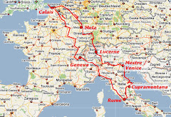
Over breakfast the next morning, we read in the local paper that the storm had been widespread and devastating, with lots of damage in the Lorraine region (around Metz and Nancy), as well as in the Ardennes where it had hit us. In particular, roads around Nancy were said to have been badly affected. This worried us because we’d decided to avoid the French toll roads (due east) and head into Germany via Nancy to the south. But we stuck to this plan, and although the road surface was disrupted in places, there was nothing bad enough to cause us problems. Two-and-a-half hours later, with no fuss whatsoever, we crossed the Europa Bruecke over the Rhine, and passed from the Avenue du Pont de l’Europe onto the Strassburger Strasse, and from France into Germany.
For quite a while before we’d crossed the border, the small towns we passed through had had German names (Steinbourg, Rosenwiller, Gotteshelm, Scherlenhelm …) and, increasingly, a south-German look; we thought of cuckoo clocks and Black Forest cherry cake. Our last French town was Strasbourg (German name, French spelling); our first German town was Kehl.
From there we headed south, between the Rhine on our right and the Naturpark Suedschwarzwald (southern Black Forest itself) on our left: a further hour and a quarter, with distant mountains gradually becoming clearer and less distant to the south as we approached the Swiss border. At that point we had to stop and buy a vignette (windscreen sticker) which showed that we had paid our annual motorway tax, entitling us to drive on Swiss motorways for a year (or at least, until December 31, when they all run out!).
We also turned on our headlamps. These are compulsory at all times in Switzerland, presumably because (as we later discovered) as you round any bend you’re likely to enter a tunnel a couple of miles long that takes you through some mountain or other. UK (and Australasian) headlamps are angled to the left to avoid dazzling oncoming drivers on your right, but of course in Europe left and right are reversed, and left-pointing headlamps is exactly what you don’t want. To cope with this, UK drivers are required to fit “headlamp converters” that mask the “bright spot” that does the dazzling. We’d fitted ours (a couple of stick-on discs) during our first stop in Belgium.
Switzerland was as much fun as we expected it to be, if you think of stunning scenery and crazy builders as “fun”. When more of your geography is vertical than horizontal, you have to be very inventive about where you build a house and how you get up to it!
It’s about three quarters of an hour from Basel to Sursee, where the river Sure (roughly, “Zooruh”) enters Lake Sempach -- in German, the Sempachersee. The E35 motorway follows the east side of the lake, and from time to time we got tantalising glimpses of beautiful scenery -- the lake itself, and the hills on the far side. Eventually, somewhere around Eich, we stopped at a picnic spot and managed to get some snaps through gaps in the trees.
At the south end of the lake is Sempach itself, and we decided to leave the motorway there and try to get down to the lake. We failed in that -- couldn't find a road that actually led to the shore, or anywhere to stop on the road we were on, appropriately called Seestrasse (“Lake Street”). It was taking us back north, parallel to the E35, but we were in plenty of time for Lucerne (our destination for the day) and decided to keep going. It was rather like driving the Glenorchy Queenstown Rd down the side of Lake Wakatipu, but don’t take the analogy too far: there aren’t many cows with cowbells round their necks grazing on the hillside pastures above Lake Wakatip!
Along the way we saw many examples of the astonishing “Swiss barns” -- in reality, combined barns and houses, with the ground floor for animals and upper floor for people. We would have liked to photograph at least one, but opportunities to pull off the road were very limited. Perhaps on the way back …
After about four miles, as we neared the north end of the lake, we passed under the motorway and decided to head off up the hillside. How could we get lost? We knew exactly where we were: Switzerland!
We saw a road sign pointing up to a place called Vogelsang, which means “Birdsong”. Irresistible! And an inspired choice. We drove up high above the lake and (cheekily) pulled into someone’s roadside parking space, adjoining a pretty house with a stunning view. We could easily see Sursee, not far to the northwest, and across the blue lake water c ould make out Oberkirch, Nottwill, and smaller communities climbing the mountainsides. And almost due south, massive snowy peaks showed above a distant, hazy horizon.
Seventeen photos later (including a panorama over the lake), we got back into the car and continued along the Vogelsangstrasse through the village itself (a modern place, from the look of it, though there were some very old-style barns), through Kirchbuehl, and back down to Sempach. As we drove through the town, we were tempted by the site of a traditional Swiss-style inn on the town square, but decided to press on to Lucerne. If we didn’t like it, or couldn’t find anywhere to stay, we could always come back.
Not like Lucerne? Only someone who’d never been there could have had such a thought. Commanding the exit of the River Reuss where it flows from the Vierwaldstattersee (which we sensibly call “Lake Lucerne”), surrounded by Alpine peaks to north, west, and south, and retaining so much of its mediaeval structure, it’s “Switzerland’s ultimate tourist destination”. We avoided the motorway, and came into the city from the north. As we crossed the river, we couldn’t help but see the amazing wooden Chapel Bridge (described below), not to mention the mediaeval churches and inns either side of the river.
On the south side of the Reuss, we circled a couple of times, looking for a hotel. Lucerne traffic is much busier than Metz’s, and Don was getting tired from driving, so in the end we picked the next one we saw with parking -- a Best Western, somewhat pricier than our usual, but a roof and a bed. It was billed as having four stars, and for sure the breakfast was good enough, but (as we’ve already written) we think we got better value with two stars in Metz.
We went for a walk through the immediate vicinity. The Chapel Bridge was just across from the end of the (short) road the hotel was in, so it was an inevitable first choice. Wooden w ith a slate roof, and dating from 1333 (originally), it takes a sort of Z-shape across the river, with a stone Wasserturm (Water Tower) about a third of the way across, which was originally the lucerna, or lighthouse, that the town is named after. (See http://travelguide.all-about-switzerland.info/lucerne-chapelbridge-watertower.html .) It was also a prison, a torture-chamber, and a treasury, but now it houses the souvenir shop where we bought our inevitable fridge magnet.
For quite a while before we’d crossed the border, the small towns we passed through had had German names (Steinbourg, Rosenwiller, Gotteshelm, Scherlenhelm …) and, increasingly, a south-German look; we thought of cuckoo clocks and Black Forest cherry cake. Our last French town was Strasbourg (German name, French spelling); our first German town was Kehl.
From there we headed south, between the Rhine on our right and the Naturpark Suedschwarzwald (southern Black Forest itself) on our left: a further hour and a quarter, with distant mountains gradually becoming clearer and less distant to the south as we approached the Swiss border. At that point we had to stop and buy a vignette (windscreen sticker) which showed that we had paid our annual motorway tax, entitling us to drive on Swiss motorways for a year (or at least, until December 31, when they all run out!).
We also turned on our headlamps. These are compulsory at all times in Switzerland, presumably because (as we later discovered) as you round any bend you’re likely to enter a tunnel a couple of miles long that takes you through some mountain or other. UK (and Australasian) headlamps are angled to the left to avoid dazzling oncoming drivers on your right, but of course in Europe left and right are reversed, and left-pointing headlamps is exactly what you don’t want. To cope with this, UK drivers are required to fit “headlamp converters” that mask the “bright spot” that does the dazzling. We’d fitted ours (a couple of stick-on discs) during our first stop in Belgium.
Switzerland was as much fun as we expected it to be, if you think of stunning scenery and crazy builders as “fun”. When more of your geography is vertical than horizontal, you have to be very inventive about where you build a house and how you get up to it!
It’s about three quarters of an hour from Basel to Sursee, where the river Sure (roughly, “Zooruh”) enters Lake Sempach -- in German, the Sempachersee. The E35 motorway follows the east side of the lake, and from time to time we got tantalising glimpses of beautiful scenery -- the lake itself, and the hills on the far side. Eventually, somewhere around Eich, we stopped at a picnic spot and managed to get some snaps through gaps in the trees.
At the south end of the lake is Sempach itself, and we decided to leave the motorway there and try to get down to the lake. We failed in that -- couldn't find a road that actually led to the shore, or anywhere to stop on the road we were on, appropriately called Seestrasse (“Lake Street”). It was taking us back north, parallel to the E35, but we were in plenty of time for Lucerne (our destination for the day) and decided to keep going. It was rather like driving the Glenorchy Queenstown Rd down the side of Lake Wakatipu, but don’t take the analogy too far: there aren’t many cows with cowbells round their necks grazing on the hillside pastures above Lake Wakatip!
Along the way we saw many examples of the astonishing “Swiss barns” -- in reality, combined barns and houses, with the ground floor for animals and upper floor for people. We would have liked to photograph at least one, but opportunities to pull off the road were very limited. Perhaps on the way back …
After about four miles, as we neared the north end of the lake, we passed under the motorway and decided to head off up the hillside. How could we get lost? We knew exactly where we were: Switzerland!
We saw a road sign pointing up to a place called Vogelsang, which means “Birdsong”. Irresistible! And an inspired choice. We drove up high above the lake and (cheekily) pulled into someone’s roadside parking space, adjoining a pretty house with a stunning view. We could easily see Sursee, not far to the northwest, and across the blue lake water c
 ould make out Oberkirch, Nottwill, and smaller communities climbing the mountainsides. And almost due south, massive snowy peaks showed above a distant, hazy horizon.
Seventeen photos later (including a panorama over the lake), we got back into the car and continued along the Vogelsangstrasse through the village itself (a modern place, from the look of it, though there were some very old-style barns), through Kirchbuehl, and back down to Sempach. As we drove through the town, we were tempted by the site of a traditional Swiss-style inn on the town square, but decided to press on to Lucerne. If we didn’t like it, or couldn’t find anywhere to stay, we could always come back.
Not like Lucerne? Only someone who’d never been there could have had such a thought. Commanding the exit of the River Reuss where it flows from the Vierwaldstattersee (which we sensibly call “Lake Lucerne”), surrounded by Alpine peaks to north, west, and south, and retaining so much of its mediaeval structure, it’s “Switzerland’s ultimate tourist destination”. We avoided the motorway, and came into the city from the north. As we crossed the river, we couldn’t help but see the amazing wooden Chapel Bridge (described below), not to mention the mediaeval churches and inns either side of the river.
On the south side of the Reuss, we circled a couple of times, looking for a hotel. Lucerne traffic is much busier than Metz’s, and Don was getting tired from driving, so in the end we picked the next one we saw with parking -- a Best Western, somewhat pricier than our usual, but a roof and a bed. It was billed as having four stars, and for sure the breakfast was good enough, but (as we’ve already written) we think we got better value with two stars in Metz.
We went for a walk through the immediate vicinity. The Chapel Bridge was just across from the end of the (short) road the hotel was in, so it was an inevitable first choice. Wooden w
 ith a slate roof, and dating from 1333 (originally), it takes a sort of Z-shape across the river, with a stone Wasserturm (Water Tower) about a third of the way across, which was originally the lucerna, or lighthouse, that the town is named after. (See http://travelguide.all-about-switzerland.info/lucerne-chapelbridge-watertower.html .) It was also a prison, a torture-chamber, and a treasury, but now it houses the souvenir shop where we bought our inevitable fridge magnet.
A striking feature as you cross is a series of captioned triangular paintings from the early 1500s, set into the roof-beams. Originally they chronicled the city's history, but the bridge was nearly destroyed by a fire in 1993, and much of what stands today is a restoration, with many empty spaces but with some original pictures that had been stored when the bridge was shortened about 100 years ago.

The other side of the river is very much “Old Town”, much of it impassable for cars. Walking through the narrow cobbled streets, we saw example after example of buildings decorated with mediaeval style carvings and paintings. A total feast for the eyes!
We crossed the river twice more, and made our way to a restaurant near the north end of the Chapel Bridge (Hotel des Alpes), where we sat by the side of the river and fed passing swans odd scraps of bread from our most delicious cheese fondue with wild mushrooms, followed by Schwarzwaldertorte (Black Forest cherry chocolate cake) for Margaret and a local cheese platter for Don. Then back across the Chapel Bridge to the hotel, and so to bed.
No comments:
Post a Comment